Hat tip:Old Time Radio Researchers for keeping these shows alive
Off the Deck

Sunday, January 04, 2026
Friday, January 02, 2026
Revisiting China's Sea Lines of Communication
In 2007, I posted on my blog a look at Sea Lines of Communication (SLOCs)(here).
Most of the links in that post are now dead or moved, but the subject is one vital to the US and other countries. One of those links contained the following from Stanley B. Weeks, a frequent SLOC commenter: "The increasing importance of SLOC security and access for states in the East Asia region will result in their increased attention to both military and non-military concerns regarding freedom of navigation. The United States, which shares the interests of the East Asian states in regional SLOC security and access, would undoubtedly welcome increased cooperation, understanding and support of regional states in upholding traditional principles of freedom of the seas so vital to seaborne trade." (1997) Also cited was a 1996 work, "Maritime Economic Interests & the Sea Lines of Communication Through the South China Sea" which can still be found at here.

Amidst other pertinent issues has this excellent map setting out "SLOC Blockages and Alternate Routes" - though it does not discuss the developing Arctic sea route above Russia, probably because it was not thought likely to be available at the time of writing.
I urge you to examine this map and contemplate what the Chinese leadership is trying to do to protect those SLOCs of vital interest to China.
Among other things, China is strongly urging its rights to the Spratly Island and to a large portion of the South China Sea. It is also seeking to protect a sea route around Australia by developing an Antarctic base or base from which shore based assets could protect shipping. Forther, China is trying to develop relationships with many of the island nations to the east of Papua New Guinea, such as the Solomons, Nauru, and others. This include an airfield on "Woleai, a remote atoll roughly 400 miles south of Guam". It should be clear why they are doing what they do - by any means - to get what they need.
China knows its greatest strategic weakness lies in its lack of internal resources and its need to control and preserve its SLOCs. In order to do so, it must find ways around the chokepoints of the first island chain that hems it in.
 |
| Blue arrows point to major chokepoints |
Figure 1. Daily transit volumes of petroleum and other liquids through world maritime oil chokepoints (million barrels per day) (2023)
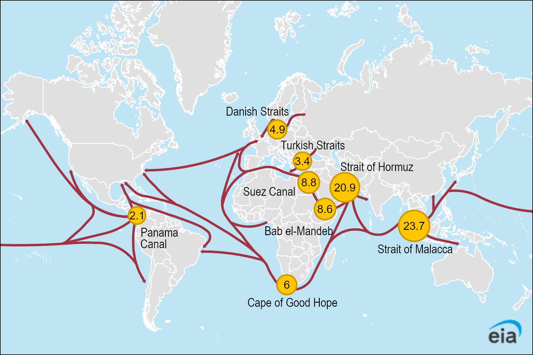
Data source: U.S. Energy Information Administration (EIA) analysis, based on Vortexa tanker tracking and Panama Canal Authority, using EIA conversion factors and calculations
Subscribe to:
Posts (Atom)