 |
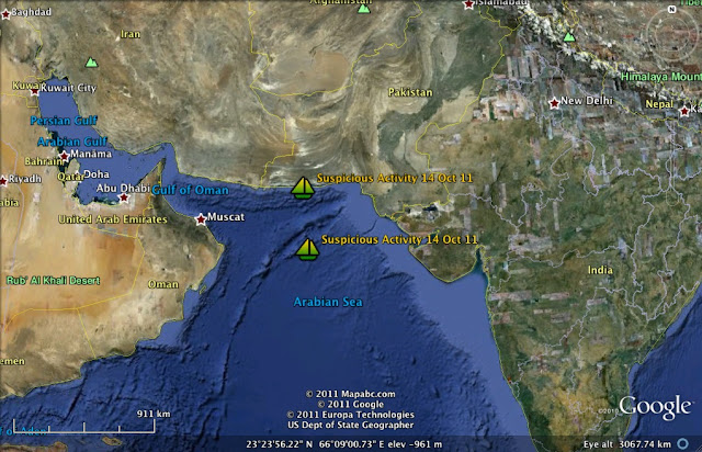
| Somali Pirate Activity Areas 10 Dec-14 Dec 2010. Distance Point A to Point B is approx 2400 miles. Attack farthest east of Somali took place about 1000 miles off Somalia. |
From the U.S. Navy Office of Naval Inteligence:
|
| Type of Search: All Anti-Shipping Activity Messages |
 |
| Pirate Attacks North Indian Ocean 10-14 Dec 2010 |
 |
| Pirate Attacks Eastern Mid-Indian Ocean 10-14 Dec 2010 |
Date Search: None |
| Sort Order: Descending Date of Occurrence |
|
 |
|
| Date of Occurrence: | 12/13/2019 | Reference Number: | 2010-527 |
| Geographical Subregion: | 62 | Geographical Location: | 13° 09' 00" N
48° 29' 00" E |
| Aggressor: | PIRATES | Victim: | MERCHANT VESSEL |
| Description: | GULF OF ADEN: Merchant vessel attacked in 13-09N 048-29E at 131000Z Dec. Vessels are advised to keep 100 miles clear of this position and to exercise extreme caution. |
| Date of Occurrence: | 12/13/2010 | Reference Number: | 2010-526 |
| Geographical Subregion: | 61 | Geographical Location: | 13° 14' 48" S
54° 43' 00" E |
| Aggressor: | PIRATES | Victim: | MERCHANT VESSELS |
| Description: | WESTERN INDIAN OCEAN: Pirate activity in 13-14.8S 054-43.0E on 13 Dec. The area involved should be avoided if possible. This area will remain high risk for at least 24-48 hours. Caution advised. |
| Date of Occurrence: | 12/11/2010 | Reference Number: | 2010-525 |
| Geographical Subregion: | 61 | Geographical Location: | 7° 33' 00" S
42° 05' 00" E |
| Aggressor: | PIRATES | Victim: | MERCHANT VESSELS |
| Description: | WESTERN INDIAN OCEAN: Piracy action group reported in 07-33S 042-05E at 111030Z Dec. Vessels passing within 100 miles are advised to exercise extreme caution. |
| Date of Occurrence: | 12/11/2010 | Reference Number: | 2010-524 |
| Geographical Subregion: | 63 | Geographical Location: | 6° 11' 00" N
67° 25' 00" E |
| Aggressor: | PIRATES | Victim: | MERCHANT VESSEL |
| Description: | SOUTHERN ARABIAN SEA: Merchant vessel attacked in 06-11N 067-25E at 110542Z Dec. Vessels passing within 100 miles are advised to exercise extreme caution. |
| Date of Occurrence: | 12/10/2010 | Reference Number: | 2010-523 |
| Geographical Subregion: | 62 | Geographical Location: | 20° 51' 00" N
62° 46' 00" E |
| Aggressor: | PIRATES | Victim: | MERCHANT VESSEL |
| Description: | ARABIAN SEA: Merchant vessel attacked in 20-51N 062-46E at 101504Z Dec. Vessels are advised to keep 100 miles clear of this position and to exercise extreme caution. |
| Date of Occurrence: | 12/10/2010 | Reference Number: | 2010-522 |
| Geographical Subregion: | 61 | Geographical Location: | 9° 57' 00" S
41° 46' 00" E |
| Aggressor: | PIRATES | Victim: | MERCHANT VESSEL |
| Description: | WESTERN INDIAN OCEAN: Merchant vessel attacked in 09-57S 041-46E at 101212Z Dec. Vessels are advised to keep 100 miles clear of this position and to exercise extreme caution. |
| Date of Occurrence: | 12/10/2010 | Reference Number: | 2010-528 |
| Geographical Subregion: | 61 | Geographical Location: | 9° 56' 00" S
41° 48' 00" E |
| Aggressor: | PIRATES | Victim: | MERCHANT VESSEL |
| Description: | INDIAN OCEAN: A merchant vessel noted being attacked by two skiffs at 1233Z on 10 Dec in position 09-56S 041-48E, approximately 123 miles northeast of Comoros. This area will remain high risk for the next 24-48 hours. |
| Date of Occurrence: | 12/10/2010 | Reference Number: | 2010-529 |
| Geographical Subregion: | 62 | Geographical Location: | 21° 05' 00" N
62° 44' 00" E |
| Aggressor: | PIRATES | Victim: | MERCHANT VESSEL |
| Description: | ARABIAN SEA: A merchant vessel noted being attacked by two skifffs at 1550Z on 10 Dec in position 21-05N 062-44E approximately 200 miles southeast of Sur, Oman. This area will remain high risk for the next 24-48 hours. |
|
From the
NATO Shipping Center:
December 15 2010
WARNING Indian Ocean
Latitude: 12°07N Longitude: 060°26E
Alert Details: Alert number 540 / 2010.
At 0215 UTC a merchant vessel was reported under attack by 2 skiffs in position 1207N 06026E.
4 POB in skiffs. RPG and machine guns sighted.
***This vessel managed to evade hijack***
The Pirate action group is still in the area.
--------------------------
December 14 2010
WARNING INDIAN OCEAN
Latitude: 18°27N Longitude: 061°50E
Alert number 539 / 2010.
At 0756 UTC 14 DEC 10 a merchant vessel was reported under attack by 2 skiffs in position 18 27N 061 50E.
Mothership was reported nearby. The vessel was fired upon by RPGs.
***This vessel managed to evade hijack***
The Pirate action group is still in the area.
------------------------
December 14 2010
WARNING Somali Basin
Latitude: 05°28 S Longitude: 039°58 E
Alert number 538/ 2010.
At 2200 UTC / 13 DEC 10 / a merchant vessel was reported under attack by 2 x skiffs in position 05 28 S 039 58 E.
2 x speedboats were used. Shots were fired upon the vessel.
***This vessel managed to evade hijack***
The Pirate action group is still in the area.
-------------------------
December 13 2010
WARNING Gulf Of Aden
Latitude: 13°09N Longitude: 048°29E
Alert number 537 / 2010.
At 1000 UTC a merchant vessel was reported under attack by 1 armed skiff in position 1309 N 04829 E.
***This vessel managed to evade hijack***
The Pirate action group is still in the area.
------------------------
December 11 2010
---ALERT UPDATE--- Indian Ocean
Latitude: 06°11N Longitude: 067°25E
Alert number 536/ 2010.
Reference previous Alert number 534/ 2010.
At 0542 UTC / 11 DEC 10 /a merchant vessel was reported under attack by pirates in position 06 11 N 067 25 E.
***This vessel has been hijacked***
-----------------------
December 11 2010
WARNING Somali Basin
Latitude: 07°33S Longitude: 042°05E
Alert number 535/ 2010.
At 1030UTC / 11 DEC 10 / a Pirate Action Group consisting of pirated FV was reported in position 07 33 S 042 05 E.
-----------------------
December 11 2010
WARNING Indian Ocean
Latitude: 06°11N Longitude: 067°25E
Alert number 534/ 2010.
At 0542UTC / 11 DEC 10 / a merchant vessel is currently under attack by pirates in position 06°11 N 067°25 E.
1 skiff with 4POB, small arms and RPG. Mother ship in vicinity of pos 3NM.
-----------------------
December 10 2010
---ALERT UPDATE--- Indian Ocean
Latitude: 21°09N Longitude: 062°45E
Alert number 533 / 2010.
Reference previous Alert number 532 / 2010.
At 101504 UTC a merchant vessel was reported under attack by pirates in position 2051N 06246E.
***This vessel managed to evade hijack***
The Pirate action group is still in the area.
-------------------------
December 10 2010
WARNING Indian Ocean
Latitude: 20°51N Longitude: 062°46E
Alert number 532/ 2010.
At 1504 UTC / 10 DEC 10 / a merchant vessel is currently under attack by pirates in position 20°51 N 062°46 E.
-------------------------
December 10 2010
---ALERT UPDATE--- Somali Basin
Latitude: 10°00S Longitude: 041°51E
Alert number 531 / 2010.
Reference previous Alert number 530 / 2010.
At 101212 UTC a merchant vessel was reported under attack by skiffs in position 0957S 04146E.
***This vessel has been hijacked***
-----------------------
December 10 2010
WARNING Somali Basin
Latitude: 09°57S Longitude: 041°46E
Alert number 530 / 2010.
At 1212 UTC / 10 DEC 10 / a merchant vessel is currently under attack by pirates in position 09°57S 041°46E
NATO "Alert" Areas as of 14 Dec 2010:


