Off the Deck

Monday, October 31, 2016
Sunday, October 30, 2016
On Midrats 30 Oct 16: Episode 356: Fall Free For All Spooktacular!
Please join us at 5pm EDT on 30 Oct 16 for Midrats Episode 356: Fall Free For All Spooktacular!
Join us live if you can, or pick the show up later by clicking here. You can also get the show later by visiting our iTunes page or at StitcherMidrats is back live! With a week left to go till the election, I am sure you are about done with all the political talk, so join us at 5pm Eastern this Sunday, October 30th as we cover the the globe on the breaking national security and maritime issues that have come up over the last month.
From FORD to KUZNETSOV; from The Baltic to Yemen we'll have it covered.
As always with our Free For Alls; it is open mic an open mind. Call in with your issues and questions, or join us in the chat room.

Saturday, October 29, 2016
Fun with Iran: "US intercepts multiple shipments of Iranian weapons going to Houthis in Yemen"
CNN reports US intercepts multiple shipments of Iranian weapons going to Houthis in Yemen
You know in case you were wondering about claims that Iran was backing the Houthis. Or about a proxy war for control of the entrance to the Red Sea at Bab el Mandeb.American warships have intercepted five shipments of weaponry to the Houthis in Yemen from Iran in the past year and a half, according to US Vice Admiral Kevin Donegan, who is in charge of American naval operations in the Middle East.
The first intercepted shipment was in April 2015 and since then, American ships have intercepted an additional four shipments, Donegan said.
The shipments included thousands of AK-47 automatic rifles, as well as anti-tank missiles and sniper rifles...

Saturday Is Old Radio Day: The Cavalcade of America "The Master Navigator"
Probably never thought you'd listen to a radio show about navigation at sea, didn't you? Well, here's a the tale of Nathaniel Bowditch, "The Master Navigator" and author of Bowditch's The American Practical Navigator:


The American Practical Navigator, first published in 1802, was billed as the "epitome of navigation" by its original author, Nathaniel Bowditch. The text has evolved with the advances in navigation practices since that first issue and continues to serve as a valuable reference for marine navigation in the modern day.I used it as a navigator on a destroyer back in the day.
The publication describes in detail the principles and factors of navigation, including piloting, electronic navigation, celestial navigation, mathematics, safety,
oceanography and meterology. It also contains various tables used in typical navigational calculations and solutions, including the formulas used to derive the tabular data.

Friday, October 28, 2016
Thursday, October 27, 2016
OPEC Fights U.S. Shale Oil, U.S. Shale Oil Hangs in There

Bloomberg has a pretty good analysis of what price levels are needed for each OPEC state to make ends meet here. Saudi Arabia needs a price point of $106, Iran $87, Venezuela $125.
Current market price for a barrel of oil is below $50. Why so low? Part of the reason is the attempt to drive U.S. shale oil producers out of business and eliminate them as competition and allow OPEC to be back in the oil pricing and demand driver seat.
There's an interesting analysis from FGE's Fereidun Fesharaki and David Isaak about why that may not be working so well from Oil & Gas Journal FGE: US unconventional industry shows resilence as OPEC reacts to shale production and prices
When the "War on Shale" began, it was common to hear that substantial drops in production would occur at $90/bbl, $80/bbl, or $70/bbl. And, it was true that to make the overall economics work, those sorts of prices were needed for many producers in certain plays. But the overall economics include the lease costs, which for some producers represents a very large fraction of the total cost. But lease costs are sunk costs, and once the investment has been made, they do not have much effect on production economics. So there are projects that might require $70/bbl to make money, but the operator can still keep producing at $40-60/bbl.So, OPEC, thanks for forcing the shale oil industry into streamlining and improving.
Some aspects of shale economics were improving at astonishing rates, even with the cushion of high prices. Total well depths typically more than doubled in the last 6 years, as did lateral runs lengths. Despite greater depths and lateral runs, typical drilling times per well were cut in half (to 17 days from 35), and some wells are now drilled in 9-12 days. In addition, multiple wells now are drilled from single production pads, meaning that the drilling equipment can be repositioned and restarted in a matter of hours rather than days.
As is widely known, productivity per well also has skyrocketed. This is the result of many factors, such as fracturing practices geared to specific local geology, improved use of proppants, and the longer total runs per well. But one of the reasons productivity is climbing is simply that the producers have begun to concentrate on the best plays.
In the early days of shale, most of the producing wells were also effectively exploration wells. In addition, many wells in the Great Rush were drilled simply because lease terms required a certain amount of drilling and output to avoid the lease reverting to the owner (leases held by production, or HBP drilling in industry jargon).
But as long as oil prices remained high, there were costs that tended to rise rather than come down. Labor was short, operating costs tended to rise, good drill rigs were at a premium, proppants and chemicals saw major price increases, and common items such as compressors were backordered. In addition, limited (and expensive) transport infrastructure cut netbacks to the wellhead.
***
Costs Have Fallen
Lower prices and increased productivity have to some extent reversed those trends. In the new low-price environment, costs have fallen-some producers report operating costs down by 20% or more. Rig counts are down, and this not only lowers the cost of rig hire, but it also means that only the best rigs are employed. Finally, although cheap transport infrastructure still falls short of demand, improvements in getting liquids to market have been steady.
That does not mean prevailing prices do not hurt. They have definitely put an end to the Great Rush. But the main effect has been to put the US shale business on a sounder footing. In the new environment, the less productive leases and plays are likely to be abandoned (which will look to the market like another major increase in well productivity). Improvements in drilling and production economics improved the bottom line before, but now additional improvements are required rather than optional.
What does this mean for production of tight oil and gas? With all the time-lags involved, it is becoming harder to assess. The large producers have slashed their E&P budgets for 2015 by about a third; and smaller producers have implemented even bigger cuts. Despite this, most of the producers report that their output of oil will be higher for 2015 than for 2014.
Monthly production declines are already occurring-although even the modest crude price revival of the last few months was enough to encourage a few producers to begin deployment of additional rigs for mid-summer. But a confounding factor is that many producers have elected to delay completions on wells that have already been drilled. Completion (casing and installation of production trees and piping) is expensive-and not needed unless the well is going into production. Some statistics suggest that as many as half of the wells drilled in the Bakken are deferring completion. Some companies (notably EOG Resources Inc. and Apache Corp., both of Houston) actually are deferring more wells in 2015 than their total new wells in 2014. This means that in the coming months and years, there may be small surges in production that are seemingly unrelated to drilling.
Crude prices need to be driven well below recent levels to put shale out of business. Conversely, mild increases in price can draw in new production comparatively rapidly. Deferred well completions add to the price responsiveness. Shale production is surprisingly resilient in the range of $50-60/bbl, and prices above $60/bbl may draw in significant new production.
And good luck on that "control of the market" thing.
The U.S., according to the U.S. Energy Information Administration seems to be sitting pretty on shale:
Does the United States have abundant shale resources?
Yes, the United States has access to significant shale resources. In the Annual Energy Outlook 2014, EIA estimated that the United States has approximately 610 Tcf of technically recoverable shale natural gas resources and 59 billion barrels of technically recoverable tight oil resources. As a result, the United States is ranked second globally after Russia in shale oil resources and is ranked fourth globally after China, Argentina and Algeria in shale natural gas resources.


Wednesday, October 26, 2016
Joke of the Day: "Iran's navy unveils 'suicide drone'"
Iran has someone with a really droll sense of humor as they announce troll the West with a weapon that is a reversion to World War II - Iran's navy unveils 'suicide drone'
Lest you forget kamikaze planes and boats and regular anti-ship cruise missiles and anti-ship guns and stuff like that, you might recall the U.S.Navy's remotely piloted bombers used in WWII:

Oh, my goodness, not those "damp sea conditions." Wait, I thought that pretty much describes what "sea" is all about . . .Iran's navy on Wednesday released a photo of what's being called a "suicide drone" that can be loaded with explosive materials and deliberately crashed into targets at sea and on land.
The announcement was carried by Iran's semi-official Tasnim news agency. While it said the drone "can carry payloads of explosives for combat missions" and collide with the target and destroy it, (whether) a vessel or an onshore command center" it also noted that the drone's primary purpose is for maritime surveillance.
It "has not been designed to be armed with missiles," Tasnim said.
The small, pilot-less aircraft can nevertheless fly for up to 4 hours and has a range of about 600 miles. It can fly as high as 3,000 feet and as low as 20 inches above the Earth's surface. Its camera can be used at night and in "damp sea conditions."

Lest you forget kamikaze planes and boats and regular anti-ship cruise missiles and anti-ship guns and stuff like that, you might recall the U.S.Navy's remotely piloted bombers used in WWII:
And, since 1903 or so, the U.S. Navy has been pretty much worried about things going after ships that go faster than 120 knots.1944 - Special Air Task Force (STAG-1) commences operations with drones, controlled by TBM Avenger aircraft, against Japanese in Southwestern Pacific.


Want to See More Sea? DARPA Has TALONS For That

One way around this limitation has been to mount sensors as high as possible on a ship, whether those sensors are lookouts in crow's nests or radar mounted at the top of a mast.
Since sensor altitude makes a difference, it is very interesting to see what DARPA is playing with in ACTUV Unmanned Vessel Helps TALONS Take Flight in Successful Joint Test:
DARPA’s Anti-Submarine Warfare (ASW) Continuous Trail Unmanned Vessel (ACTUV) program has developed and built a technology demonstration vessel that is currently undergoing open-water testing off the coast of California and recently set sail with its first payload: a prototype of a low-cost, elevated sensor mast developed through the Agency’s Towed Airborne Lift of Naval Systems (TALONS) research effort.Expanding the ranges of detection through use of unmanned vessels is vital to protecting those higher value units that do contain humans.
ACTUV seeks to lay the technical foundation for an entirely new class of ocean-going vessel—one able to traverse thousands of kilometers over the open seas for months at a time, without a single crew member aboard. Potential missions include submarine tracking and countermine activities. Towed behind boats or ships, TALONS could persistently carry intelligence, surveillance, reconnaissance (ISR), and communications payloads of up to 150 pounds between 500 and 1,500 feet in altitude—many times higher than current ships’ masts—and greatly extend the equipment’s range and effectiveness.
***
While aloft, TALONS demonstrated significant improvements to the range of the sensors and radios it carried compared to mounting them directly on a surface vessel. For example, TALONS’ surface-track radar extended its range by 500 percent—six times—compared to its range at sea level. Its electro-optical/infrared scanner doubled its observed discrimination range. The TALONS team plugged in a commercial handheld omnidirectional radio; that radio’s range more than tripled.
UPDATE: Yes, adding altitude to ship sensors is not a new idea - see the Coast Guard's sea based aerosat program from the 1980s:
During the 1980s as a result of the increased illegal traffic of narcotics and migrants in the Caribbean, the Coast Guard established the Mobile Aerostat Program. It consisted of two shore-based units located in Key West and Miami, Florida. The units were comprised of two teams per vessel (total of five) which alternately deployed aboard Sea Based Aerostat (SBA) Platforms. Aerostats were unmanned lighter-than-air aircraft which mounted sophisticated radar and other surveillance equipment. The MAP mission was to provide continuous air and surface surveillance for other law enforcement units working in the same geographic area of responsibility. SBAs normally worked in conjunction with high and medium endurance cutters and patrol boat class vessels. Successful operations were conducted with other U. S. and foreign naval forces. From 1984 to the program's decommissioning on 31 March 1992, the Aerostats provided target information resulting in numerous drug seizures and illegal alien interdictions.


Of course, that was before we had cool, unmanned vessels to tow sensors around.
Tuesday, October 25, 2016
Early Voted. Came home and washed my hands. Wished I could wash my brain.
So, here's what the blank ballot looked like for the "presidential" choices:

Sometimes there is no "least bad choice."
I wrote in a name in the space provided.
If I wasted my vote on in write-in, at least I kept my faith with my fellow citizens.
Came home and washed my hands to rid myself of the stink of the major party candidates.
But the horror remains.
We cannot do this to ourselves again.
There are good and honorable people out there. We must support them.
Somali Pirates Release Victims After Long Capture
NYTimes reportFreed Sailors Recount Years of Torture at the Hands of Somali Pirates:
The pirates have a bad business model that does not reflect the current realities of their operating area. Essentially, their current targets will be the crews of outlaw fishing boats which intrude on Somali waters. It's a high risk venture with low rewards if only the costs are being covered.. . .during which the crew members were beaten with bamboo poles, ate rats to survive and were held at gunpoint in a sweltering stretch of Somalian desert by a band of pirates who were convinced they were going to make many millions of dollars.
It all ended this weekend. The pirates finally relented, accepting a smaller amount to release the 26 surviving members of the Naham 3 crew after one of the longest pirate hostage ordeals ever endured.
***
Mr. Libres, a Filipino sailor, seemed almost confused about how his captors could be so heartless. “The pirates are worse than animals,” he
said. “You can’t understand these people.”
***
Still, dozens of sailors remained in captivity from earlier attacks. Negotiators had been working for years to free the crew of the Naham 3, an Omani-flagged vessel hijacked while fishing for tuna near the Seychelles.
“The pirates were uneducated, obstructionist, unmotivated and unrealistic,” said Leslie Edwards, the lead negotiator for the sailors’ release. “They picked poor fishermen from poor countries from poor families. They were dreaming about huge amounts of money they were never going to get.”
In the end, negotiators worked with clan elders in Somalia to persuade the pirates to accept a relatively small amount of money to cover the costs of holding the captives for 1,672 days. The negotiators did not disclose the amount, though they said it was “nothing” compared with what the pirates originally demanded. A British law firm helped raise the money, and the rescue mission was coordinated by Oceans Beyond Piracy, a project run by an American nonprofit organization.


Monday, October 24, 2016
Saturday, October 22, 2016
Saturday Is Old Radio Day: "John Steele, Adventurer"
About John Steele, Adventurer:
As he says in the opening of the following show,John Steele was the type of roving adventurer and thrill seeker who held various jobs in exotic locations. Among his career paths were country sheriff, special agent in Turkey and a ship’s captain.

"At best in a lifetime we experience one exciting moment that makes for a real story, yet each one of us has had one such happening that stands out above all the rest . . ."
Friday, October 21, 2016
Thursday, October 20, 2016
"U.S. has lost" - Philippines Chooses the Strong Horse says its President
Leadership is an odd thing, since so much of it depends on perception - and the current president of the Philippines has perceived that China is the big dog in his region, as Reuters reports in "Duterte says U.S. has lost, aligns Philippines with China":
UPDATE: Vietnam announces an "enemy of my enemy is my friend" hedging strategy as set out here:
Lord Palmerston had it right:Philippine President Rodrigo Duterte announced his "separation" from the United States on Thursday, declaring that it had "lost" and he had realigned with China as the two agreed to resolve their South China Sea dispute through talks.
Duterte made his comments in China, where he is visiting with at least 200 business people to pave the way for what he calls a new commercial alliance as relations with longtime ally the United States deteriorate.
His trade secretary, Ramon Lopez, said $13.5 billion in deals would be signed
Duterte's efforts to engage China, months after a tribunal ruling in the Hague over South China Sea disputes in favor of the Philippines, marks a reversal in foreign policy since the 71-year-old former mayor took office on June 30.
"America has lost now," Duterte told Chinese and Philippine business people at a forum in the Great Hall of the People, attended by Chinese Vice Premier Zhang Gaoli.
"I've realigned myself in your ideological flow and maybe I will also go to Russia to talk to (President Vladimir) Putin and tell him that there are three of us against the world - China, Philippines and Russia. It's the only way," he added.

“We have no eternal allies, and we have no perpetual enemies. Our interests are eternal and perpetual, and those interests it is our duty to follow.”President Duterte may not be everyone's cup of tea, but he does seem to have a strong view of where the interests of the Republic of the Philippines lie. He's decided that China is the stronger horse, or as that now dead chap Osama bin Laden said:
“When people see a strong horse and a weak horse, by nature, they will like the strong horse”While thinking about protecting U.S. interests in the Pacific, it might be time to look hard at those islands that are U.S. territory out there in the Pacific, like Wake, Midway, etc, and building up our attack submarine force.
UPDATE: Vietnam announces an "enemy of my enemy is my friend" hedging strategy as set out here:
Vietnam supports US “intervention” in the Asia-Pacific if it helps keep peace and stability, the defence ministry said, in a timely endorsement of a continued U.S. presence amid uncertainty over Washington’s faltering “pivot”.You might note that Vietnam has couched its "support" with a few "ifs."
Vice-defence minister, Senior Lieutenant General Nguyen Chi Vinh, met on Monday with Cara Abercrombie, the US Deputy Assistant Secretary of Defence for South and Southeast Asia, and told her Vietnam backed a positive US role.
The general’s words of support, conveyed by a normally reclusive defence ministry, come when the United States most needs them, with its “rebalance” – aimed at boosting its Asian foothold and tempering China’s rise – now under strain in the run-up to a US presidential election.
Vinh “affirmed that Vietnam will support the US and other partners to intervene in the region as long as it brings peace, stability and prosperity”, he said in a statement.
Vietnam will support the US and other partners to intervene in the region as long as it brings peace, stability and prosperity.
At the dialogue, Abercrombie said the United States would not change its rebalance strategy, the statement added.
***
Washington’s traditional defence alliances in Southeast Asia are currently being tested, with ties with Thailand frosty since a 2014 coup and questions about the future of a tight military relationship with the Philippines under volatile new President Rodrigo Duterte, a staunch US critic.
Wednesday, October 19, 2016
Fun with Iran: Iran's Single-Handed Battle with "Somali Pirates" goes on and on
While the rest of the world's merchant fleets have enjoyed a respite from Somali pirate attacks ("Sea piracy drops to 21-year low"), Iran's apparently "pirate magnet" merchant shipping continues to suffer - at least according to the fabulistic Iranian media - with reports like this from Iran's Mehr "News" Agency "Navy’s 44th fleet thwarts pirate attacks in Gulf of Aden":
The "uncharted waters" of the northern Indian Ocean? Really? I guess the thousands of ships plying those waters must be lost and lucky to find there way from one port to another. Good thing they all have GPS to keep them informed of their location or they would have to wait for the Iranian's 44th Fleet (a two-ship "fleet?") to chart those water for them.
Why the Iranians bother with these bogus reports is quite the question, but they do provide some comic relief, so they've got that going for them.
By way of example, let's look at the nice maps provided by our friends at International Maritime Bureau's Live Piracy Map:
Hmm. Thanks to a number of naval forces and the continuing use of armed guards on merchant ships, there seems to be a remarkable lack of pirate action out there in the northern Indian Ocean, doesn't there?
And, as noted here several times, Iran's "fleet" consists of what most folks would call a "frigate" and a as its companion.

 All of this must be meant for internal consumption, because no one else could fall for this nonsense.
TEHRAN, Oct. 17 (MNA) – Iran’s 44th naval fleet has foiled pirate attacks on two Iranian tankers during days of its presence in the open waters and the Gulf of Aden.Good golly, there are enough fabrications in those few paragraphs to sink the Iranian "logistical destroyers" without any assaults by hordes of pirate speedboats.
Early on Monday morning, pirates of Gulf of Aden, who mainly come from Somali coasts, sought to carry out a raid and highjack an Iranian merchant ship though they were forced to flee following a heavy exchange of fire by 44th Fleet of Army’s Navy.
On two more occasions, first with eight pirate speedboats at 46 miles to south of Aden and later with thirteen well-equipped boats at 55 miles to south of Yemen, pirates were about to launch an assault on another Iranian vessel but they were forced to retreat when they came under heavy fire from the 44th fleet of the Iranian navy.
Navy’s 44th Fleet, consisting of Alvand and Bushehr logistical destroyers, had left Bushehr to explore uncharted waters on October 05.
The "uncharted waters" of the northern Indian Ocean? Really? I guess the thousands of ships plying those waters must be lost and lucky to find there way from one port to another. Good thing they all have GPS to keep them informed of their location or they would have to wait for the Iranian's 44th Fleet (a two-ship "fleet?") to chart those water for them.
Why the Iranians bother with these bogus reports is quite the question, but they do provide some comic relief, so they've got that going for them.
By way of example, let's look at the nice maps provided by our friends at International Maritime Bureau's Live Piracy Map:
 |
| 2016 to date |
 |
| 2015 |
Hmm. Thanks to a number of naval forces and the continuing use of armed guards on merchant ships, there seems to be a remarkable lack of pirate action out there in the northern Indian Ocean, doesn't there?
And, as noted here several times, Iran's "fleet" consists of what most folks would call a "frigate" and a as its companion.
Monday, October 17, 2016
U.S. Navy Office of Naval Intelligence Worldwide Threat to Shipping (WTS) Report 13 September - 12 October 2016
Special Warning for the Bab-el-Mandeb chokepoint:
NGA Special Warning 134: Red Sea, Bab-el-Mandeb Strait and Gulf of Aden Commercial vessels in the region of the Red Sea, Bab el Mandeb Strait and the Gulf of Aden should operate under a heightened state of alert as increasing tensions in the region escalate the potential for direct or collateral damage to vessels transiting the region. These threats may come from a variety of different sources such as missiles, projectiles or waterborne improvised explosive devices. Houthi rebels claimed responsibility for an 01 October attack on a UAE vessel. Vessels in the region should report hostile activities immediately and contact coalition naval forces . . .
U.S. Navy Office of Naval Intelligence Worldwide Threat to Shipping (WTS) Report 13 September - 12 October... by lawofsea on Scribd
Saturday, October 15, 2016
Saturday Is Old Radio Day: Suspense "The Man in the Fog"
From Suspense:
The show's opening phrase was often parodied, as in this Mad Magazine cover:

Here's show from 1961:Suspense is a radio drama series broadcast on CBS Radio from 1942 through 1962.

The show's opening phrase was often parodied, as in this Mad Magazine cover:

Friday, October 14, 2016
Thursday, October 13, 2016
Fun with Iran: The Yemen Missile Gambit

1. Someone shoots at U.S. ships
2. U.S. responds
3. Iran asserts U.S. made "decision to directly get involved in a Saudi-led war against Yemen." Iran twists self-defense into offensive act.
See here:
The presence of the Iranian fleet in the Gulf of Aden coincides with the US decision to directly get involved in a Saudi-led war against Yemen.Or, as one of my kids used to tattle: "Doug hit me back."
On Thursday, the US military launched cruise missile strikes to destroy coastal radar sites in Yemen in retaliation for an alleged missile attacks on a US Navy destroyer.
I think the Persians were early players of chess.
Counterstrike: U.S. Navy Strikes Radar Sites in Yemen Involved in Recent Missile Launches
Freedom of the seas means not letting bad guys take potshots at ships at sea. Nothing like a little firework to celebrate your 241st birthday, U.S. Navy!
Official Navy headline reads U.S. Military Strikes Radar Sites in Yemen Involved in Recent Missile Launches Threatening USS Mason, but
As a side note, Iran is sending a frigate and a replenishment ship to the Gulf of Aden in what looks to me like one of their routine counter-piracy patrols, as set out here:
The following is a statement released today by Pentagon Press Secretary Peter Cook on U.S. military strikes against radar sites in Yemen:
"Early this morning local time, the U.S. military struck three radar sites in Houthi-controlled territory on Yemen's Red Sea coast. Initial assessments show the sites were destroyed. The strikes -- authorized by President Obama at the recommendation of Secretary of Defense Ash Carter and Chairman of the Joint Chiefs General Joseph Dunford -- targeted radar sites involved in the recent missile launches threatening USS Mason and other vessels operating in
international waters in the Red Sea and the Bab al-Mandeb. These limited self-defense strikes were conducted to protect our personnel, our ships, and our freedom of navigation in this important maritime passageway. The United States will respond to any further threat to our ships and commercial traffic, as appropriate, and will continue to maintain our freedom of navigation in the Red Sea, the Bab al-Mandeb, and elsewhere around the world."
The guided missile destroyer USS Nitze (DDG 94) launches a strike against three coastal radar sites in Houthi-controlled territory on Yemen's Red Sea coast.


As a side note, Iran is sending a frigate and a replenishment ship to the Gulf of Aden in what looks to me like one of their routine counter-piracy patrols, as set out here:
As do a billion other things.Iran’s 44th fleet, comprised of Alvand destroyer and Bushehr logistic warship, has been dispatched to the Gulf of Aden and the Bab el-Mandeb Strait to protect the country’s trade vessels against piracy in the unsafe zone.
The Iranian fleet will head for the waters near Somalia and Tanzania afterwards through the Indian Ocean.
After making a port call in Tanzania, the 44th fleet will sail along the eastern coasts of Africa if the weather holds out, and is scheduled to sail even for the western coasts of South Africa, in the South Atlantic Ocean.
The presence of the Iranian fleet in the Gulf of Aden coincides with the US decision to directly get involved in a Saudi-led war against Yemen.


Tuesday, October 11, 2016
Reducing U.S. Hurricane Deaths: Evacuate Early and Don't Drive into Water on the Road
People die in hurricanes, see here, which lists 21 deaths from hurricane Matthew. In North Carolina, we've had 14 of those deaths. The large majority of which involved people dying because they drove their cars into high water and got
 trapped or swept away or otherwise put themselves in a position to drown.
Back when the death toll was slightly lower, there was this:
If it's true for hurricanes, it's also true for thunderstorms, as set out here:
Oh, and when given the warning to evacuate before a storm, evacuate. When the water begins to rise around you, an attempt to drive out then may just kill you. So pack up all your valuables and get out early. There's always higher ground to be found before the storm.

Back when the death toll was slightly lower, there was this:
The 11 deaths in North Carolina included some victims who drowned after driving onto flooded roads.More here:
"I cannot stress more: If you see a road that's flooded, do not take your car through that road," McCrory said. "If you see a barrier, do not go around that barrier."
Fourteen people have been killed in the state, most of them occurring when motorists were swept away on flooded roads, McCrory said during a Tuesday morning press conference.In addition to the deaths, people driving into flood waters who do not get killed need to be rescued, which places their rescuers in dangerous situations.
One person was killed in Johnson County when their car was washed away, McCrory said Monday.
McCrory said during a press conference Saturday that one person died in Sampson County after their vehicle hydroplaned in heavy rain. Two others were killed in Bladen County when their vehicle became submerged.
A fourth victim drowned in Harnett County after the victim drove past a barricade and was swept away into a creek, the county sheriff told FOX8.
***
During a Sunday morning press conference, the governor said two deaths were also reported in Johnston County and one in Pittman County.
The News & Observer reported that one of the deaths was 19-year-old Diamond Shuntelle Bennett, whose car was swept away in flood waters on Interstate 95 near Four Oaks on Saturday night, according to Capt. Jeremy Johnson of the Four Oaks Fire Department.
One person died after five people were trapped inside a submerged Nissan Versa in Cleveland.
“Four escaped and were able to cling to trees until rescue arrived,” State Highway Patrol spokesman Lt. Jeff Gordon told The News & Observer. “The other they’re still looking for and is presumed deceased.”
A 63-year-old woman, who was on her way home from her nursing job at a long-term care facility, clung to a tree for three hours after floodwaters from Hurricane Matthew swept her car into a canal in Wilson, AP reports.
***
North Carolina Highway Patrol troopers helped 25 vehicles after they became stranded on Interstate 95 Saturday. The cars got caught on a stretch of road between two parts of the flooded highway.
State officials say emergency responders have conducted at least 77 water rescues from cars and homes in Fayetteville alone, according to The News & Observer, including the dramatic rescue of a woman and her child from a car that got caught up in the floodwaters.
If it's true for hurricanes, it's also true for thunderstorms, as set out here:
Each year, more deaths occur due to flooding than from any other thunderstorm related hazard. The Centers for Disease Control and Prevention report that over half of all flood-related drownings occur when a vehicle is driven into hazardous flood water. The next highest percentage of flood-related deaths is due to walking into or near flood waters. People underestimate the force and power of water. Many of the deaths occur in automobiles as they are swept downstream. Of these drownings, many are preventable, but too many people continue to drive around the barriers that warn you the road is flooded. A mere 6 inches of fast-moving flood water can knock over an adult. It takes just 12 inches of rushing water to carry away a small car, while 2 feet of rushing water can carry away most vehicles. It is NEVER safe to drive or walk into flood waters.Want to reduce hurricane tragedies? Turn around, don't drown.
Oh, and when given the warning to evacuate before a storm, evacuate. When the water begins to rise around you, an attempt to drive out then may just kill you. So pack up all your valuables and get out early. There's always higher ground to be found before the storm.
Monday, October 10, 2016
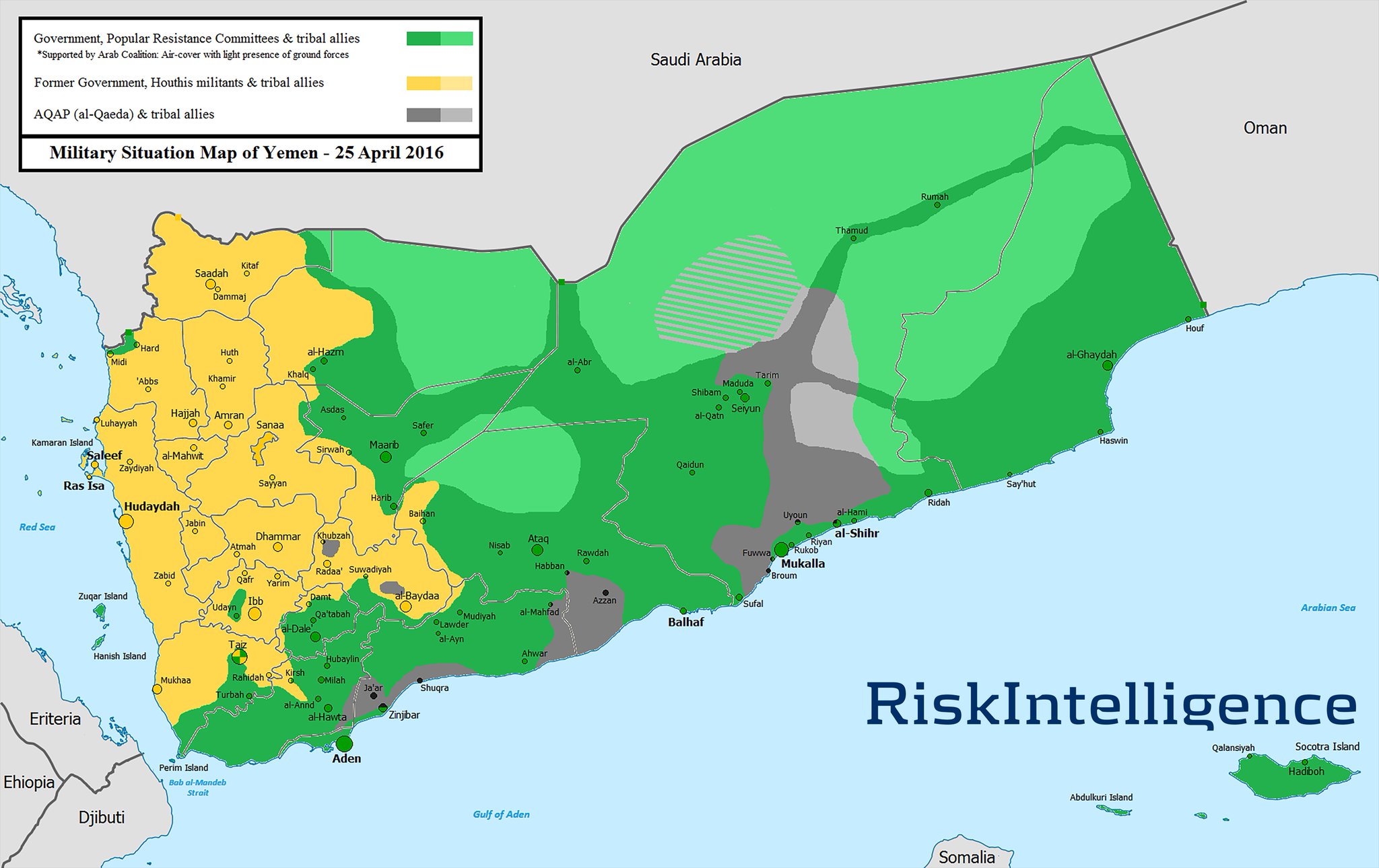
Missile Attacks Off Yemen and the Iran- Saudi Proxy War for Oil Shipping Chokepoints
Some party to the Yemen "civil war" has been shooting missiles at ships off the Yemeni coast, including unsuccessfully firing a couple at U.S. Navy warships operating off that coast, as reported at Missiles fired from rebel-held Yemen land near Norfolk-based USS Mason and an earlier attack on a former USNS leased vessel, as reported at Former U.S. Navy HSV-2 Swift wrecked in Yemen missile attack.
Why would the "rebels" be doing this?
The "civil war" in Yemen is widely viewed as a Saudi v. Iran proxy war with the U.S. on the side of the Saudis, making it a Iran v.U.S. Proxy war.
Things are pretty much a mess in Yemen as various Shiite and Sunni groups attempt to push the others around in order to gain control of key areas of Yemen. Pretty good explanation from the BBC of Yemen crisis: Who is fighting whom?:
But focus on this - Iran is Saudi Arabia's enemy.
Iran would like to control the Saudi outflow of oil. It can do so by shutting down Saudi access through the Strait of Hormuz except that the Saudi's can also export oil from their west coast on the Red Sea and ship it through the Bab el-Mandeb Strait. If the Iranian surrogate Houthis can gain control of the Bab el-Mandeb Strait then Iran could, effectively, throttle Saudi oil flow.
The chokepoint situation had been discussed here many time, but the U.S.Energy Information Administration has a great site, World Oil Transit Chokepoints which lays these routes out well:
You know, world domination.
And that's why Yemen.
Why would the "rebels" be doing this?
The "civil war" in Yemen is widely viewed as a Saudi v. Iran proxy war with the U.S. on the side of the Saudis, making it a Iran v.U.S. Proxy war.
 |
| map source |
The main fight is between forces loyal to the beleaguered President, Abdrabbuh Mansour Hadi, and those allied to Zaidi Shia rebels known as Houthis, who forced Mr Hadi to flee the capital Sanaa in February. {2015}If you feel you need a scorecard to keep track, you are not alone.
***
Yemen's security forces have split loyalties, with some units backing Mr Hadi, and others the Houthis and Mr Hadi's predecessor Ali Abdullah Saleh, who has remained politically influential. Mr Hadi is also supported in the predominantly Sunni south of the country by militia known as Popular Resistance Committees and local tribesmen.
Both President Hadi and the Houthis are opposed by al-Qaeda in the Arabian Peninsula (AQAP), which has staged numerous deadly attacks from its strongholds in the south and south-east.
The picture is further complicated by the emergence in late 2014 of a Yemen affiliate of the jihadist group Islamic State, which seeks to eclipse AQAP and claims it carried out a series of suicide bombings in Sanaa in March 2015.
After rebel forces closed in on the president's southern stronghold of Aden in late March, a coalition led by Saudi Arabia responded to a request by Mr Hadi to intervene and launched air strikes on Houthi targets. The coalition comprises five Gulf Arab states and Jordan, Egypt, Morocco and Sudan.
***
The conflict between the Houthis and the elected government is also seen as part of a regional power struggle between Shia-ruled Iran and Sunni-ruled Saudi Arabia, which shares a long border with Yemen.
Gulf Arab states have accused Iran of backing the Houthis financially and militarily, though Iran has denied this, and they are themselves backers of President Hadi.
Yemen is strategically important because it sits on the Bab al-Mandab strait, a narrow waterway linking the Red Sea with the Gulf of Aden, through which much of the world's oil shipments pass. Egypt and Saudi Arabia fear a Houthi takeover would threaten free passage through the strait.
But focus on this - Iran is Saudi Arabia's enemy.
Iran would like to control the Saudi outflow of oil. It can do so by shutting down Saudi access through the Strait of Hormuz except that the Saudi's can also export oil from their west coast on the Red Sea and ship it through the Bab el-Mandeb Strait. If the Iranian surrogate Houthis can gain control of the Bab el-Mandeb Strait then Iran could, effectively, throttle Saudi oil flow.
The chokepoint situation had been discussed here many time, but the U.S.Energy Information Administration has a great site, World Oil Transit Chokepoints which lays these routes out well:
World chokepoints for maritime transit of oil are a critical part of global energy security. About 63% of the world's oil production moves on maritime routes. The Strait of Hormuz and the Strait of Malacca are the world's most important strategic chokepoints by volume of oil transit.So, it's all about the oil. If Iran can control oil flowing out of the Middle East, it can control prices and, I assume it believes, the behavior of those nations dependent upon that oil.
***
The Strait of Hormuz is the world's most important chokepoint with an oil flow of
17 million barrels per day in 2013, about 30% of all seaborne-traded oil.
Located between Oman and Iran, the Strait of Hormuz connects the Persian Gulf with the Gulf of Oman and the Arabian Sea. The Strait of Hormuz is the world's most important oil chokepoint because of its daily oil flow of 17 million barrels per day in 2013. Flows through the Strait of Hormuz in 2013 were about 30% of all seaborne-traded oil.
EIA estimates that more than 85% of the crude oil that moved through this chokepoint went to Asian markets, based on data from Lloyd's List Intelligence tanker tracking service.6 Japan, India, South Korea, and China are the largest destinations for oil moving through the Strait of Hormuz.
***
At its narrowest point, the Strait of Hormuz is 21 miles wide, but the width of the shipping lane in either direction is only two miles wide, separated by a two-mile buffer zone. The Strait of Hormuz is deep and wide enough to handle the world's largest crude oil tankers, with about two-thirds of oil shipments carried by tankers in excess of 150,000 deadweight tons.
***
Pipelines available as bypass options
Most potential options to bypass Hormuz are currently not operational. Only Saudi Arabia and the United Arab Emirates (UAE) presently have pipelines able to ship crude oil outside of the Persian Gulf and have additional pipeline capacity to circumvent the Strait of Hormuz. At the end of 2013, the total available unused pipeline capacity from the two countries combined was approximately 4.3 million bbl/d (see Table 2).
Saudi Arabia has the 746-mile Petroline, also known as the East-West Pipeline, which runs across Saudi Arabia from its Abqaiq complex to the Red Sea. The Petroline system consists of two pipelines with a total nameplate (installed) capacity of about 4.8 million bbl/d. The 56-inch pipeline has a nameplate capacity of 3 million bbl/d, and its current throughput is about 2 million bbl/d. The 48-inch pipeline had been operating in recent years as a natural gas pipeline, but Saudi Arabia converted it back to an oil pipeline. The switch increased Saudi Arabia's spare oil pipeline capacity to bypass the Strait of Hormuz from 1 million bbl/d to 2.8 million bbl/d, but this is only achievable if the system operates at its full nameplate capacity.
Saudi Arabia also operates the Abqaiq-Yanbu natural gas liquids pipeline, which has a capacity of 290,000 bbl/d. However, this pipeline is currently running at capacity and cannot move any additional oil.
The UAE operates the Abu Dhabi Crude Oil Pipeline (1.5 million bbl/d) that runs from Habshan, a collection point for Abu Dhabi's onshore oil fields, to the port of Fujairah on the Gulf of Oman, allowing crude oil shipments to circumvent the Strait of Hormuz. The pipeline can transport more than half of UAE's total net oil exports. The government plans to increase this capacity in the near future to 1.8 million bbl/d.
***
Suez Canal
The Suez Canal is located in Egypt and connects the Red Sea and Gulf of Suez with the Mediterranean Sea. In 2013, total petroleum and other liquids (crude oil and refined products) and LNG accounted for 20% and 3% of total Suez cargoes, measured by cargo tonnage, respectively. The Suez Canal is unable to handle Ultra Large Crude Carriers (ULCC) and fully laden Very Large Crude Carriers (VLCC) class crude oil tankers. The Suezmax was the largest ship capable of navigating through the canal until 2010 when the Suez Canal Authority extended the canal depth to 66 feet to allow more than 60% of all tankers to use the Suez Canal, according to the Suez Canal Authority.15
In 2013, nearly 3.2 million bbl/d of total oil (crude oil and refined products) transited the Suez Canal in both directions, according to the Suez Canal Authority. This is the largest amount ever shipped through the Suez Canal. The majority of the oil was sent northbound (1.9 million bbl/d) toward European and North American markets, and the remainder was sent southbound (1.3 million bbl/d), mainly toward Asian markets.
Oil exports from Persian Gulf countries (Saudi Arabia, Iraq, Kuwait, United Arab Emirates, Iran, Oman, Qatar, and Bahrain) accounted for 79% of Suez Canal northbound oil flows. The largest importers of northbound oil flows through the Suez Canal in 2013 were European countries (68%) and the United States (16%). Oil exports from European countries made up the majority (66%) of Suez southbound oil flows, followed by North Africa (Algeria and Libya combined made up 16%). The largest importers of Suez southbound oil flows through the Suez Canal were Asian countries (74%).
Total traffic through the Suez Canal fell in 2009, and total oil flows dropped to 1.8 million bbl/d, their lowest level in recent years. The decrease in oil flows during that time reflected the collapse in world oil market demand that began in the fourth quarter of 2008, followed by OPEC production cuts (primarily from the Persian Gulf), which caused a sharp fall in regional oil trade starting in early 2009. Egypt's 2011 revolution did not have any noticeable effect on oil transit flows through the Suez Canal. Over the past few years, oil flows through the Suez Canal have increased, recovering from previous lower levels during the global economic downturn.
SUMED Pipeline
The 200-mile long SUMED Pipeline, or Suez-Mediterranean Pipeline, transports crude oil through Egypt from the Red Sea to the Mediterranean Sea. The crude oil flows through two parallel pipelines that are 42 inches in diameter, with a total pipeline capacity of 2.34 million bbl/d. Oil flows north starting at the Ain Sukhna terminal along the Red Sea coast to its end point at the Sidi Kerir terminal on the Mediterranean Sea. SUMED is owned by the Arab Petroleum Pipeline Co., a joint venture between the Egyptian General Petroleum Corporation (50%), Saudi Aramco (15%), Abu Dhabi's International Petroleum Investment Company (15%), multiple Kuwaiti companies (15%), and Qatar Petroleum (5%).16
The SUMED Pipeline is the only alternative route to transport crude oil from the Red Sea to the Mediterranean Sea if ships were unable to navigate through the Suez Canal. Closure of the Suez Canal and the SUMED Pipeline would necessitate diverting oil tankers around the southern tip of Africa, the Cape of Good Hope, adding approximately 2,700 miles to transit from Saudi Arabia to the United States, increasing both costs and shipping time, according to the U.S. Department of Transportation.17 According to the International Energy Agency (IEA), shipping around Africa would add 15 days of transit to Europe and 8-10 days to the United States.18
Fully laden VLCCs going toward the Suez Canal also use the SUMED Pipeline for lightering. Lightering occurs when a vessel needs to reduce its weight and draft by offloading cargo to enter a restrictive waterway, such as a canal. The Suez Canal is not deep enough for a fully-laden VLCC and, therefore, a portion of the crude is offloaded at the SUMED Pipeline at the Ain Sukhna terminal. The now partially-laden VLCC goes through the Suez Canal and picks up the offloaded crude at the other end of the pipeline at the Sidi Kerir terminal.
In 2013, 1.4 million bbl/d of crude oil was transported through the SUMED Pipeline to the Mediterranean Sea, which was then loaded onto a tanker for seaborne trade. SUMED crude flows decreased over the past few years, but the decrease has been offset by more oil transiting northbound via the Suez Canal. Total oil flows via SUMED and the Suez Canal were 4.6 million bbl/d in 2013, 0.1 million bbl/d higher compared with the previous year. Total oil flows via the Suez Canal and SUMED pipeline accounted for about 8% of total seaborne-traded oil in 2013.
***
Bab el-Mandeb
Closing the Bab el-Mandeb Strait could keep tankers in the Persian Gulf from reaching
the Suez Canal and the SUMED Pipeline, diverting them around the southern tip of Africa.
The Bab el-Mandeb Strait is a chokepoint between the Horn of Africa and the Middle East, and it is a strategic link between the Mediterranean Sea and the Indian Ocean. The strait is located between Yemen, Djibouti, and Eritrea, and connects the Red Sea with the Gulf of Aden and the Arabian Sea. Most exports from the Persian Gulf that transit the Suez Canal and SUMED Pipeline also pass through Bab el-Mandeb.
An estimated 3.8 million bbl/d of crude oil and refined petroleum products flowed through this waterway in 2013 toward Europe, the United States, and Asia, an increase from 2.9 million bbl/d in 2009. Oil shipped through the strait decreased by almost one-third in 2009 because of the global economic downturn and the decline in northbound oil shipments to Europe. Northbound oil shipments increased through Bab el-Mandeb Strait in 2013, and more than half of the traffic, about 2.1 million bbl/d, moved northbound to the Suez Canal and SUMED Pipeline.
The Bab el-Mandeb Strait is 18 miles wide at its narrowest point, limiting tanker traffic to two 2-mile-wide channels for inbound and outbound shipments. Closure of the Bab el-Mandeb could keep tankers from the Persian Gulf from reaching the Suez Canal or SUMED Pipeline, diverting them around the southern tip of Africa, adding to transit time and cost. In addition, European and North African southbound oil flows could no longer take the most direct route to Asian markets via the Suez Canal and Bab el-Mandeb.


You know, world domination.
And that's why Yemen.
 |
| map source |
Saturday, October 08, 2016
Saturday Is Old Radio Day - Hurricane Story - "Key Largo"
As Hurricane Matthew rolls along, her, from Lux Radio Theater, starring Bogart,
 Bacall, and Edward G. Robinson reprising their movie roles in "Key Largo"
Friday, October 07, 2016
Tuesday, October 04, 2016
Hurricane Matthew
For the next few days I'm going to be donning my Red Cross hat and engaging in some weather watching of Hurricane Matthew. Those of you not on the U.S. East Coast can worry about the other things that are natural or unnatural disasters, but we've got a bad storm rolling around with a big "cone of uncertainty" so
In any event, the National Hurricane Center is tracking Matthew and so we will too.
Here are some early graphics from the NHC:


Don't panic but if you live on the East Coast, you might want to be carefully thinking about what you need to do to prepare for a storm like Matthew. And, it's not just those of you who live on the beach, either - we've had lots of rain recently and the ground in many areas is pretty saturated so trees may topple and your power may go out, so . . . in addition, given the cone of uncertainty, this storm could (had to assign a probability) move more westerly and run inland with heavy rain and wind. We won't know for a few days really, because anyone selling you a forecast more than 72 hours out is SWAGing it.
Prepare for the worst, hope for the best.
Here's an older post on prepping for disaster, Are You Prepared for a Hurricane? Earthquake? Flood? which you might find useful:
If you are trapped in your house by flooding, stay there and keep out of the water by moving upward. It's a lot easier to be plucked off your roof than it is to be rescued from flooded rivers and streams. Now is the time, though, to develop a plan. That plan may include getting the heck out of areas at risk and heading to the hills. Trust me, sleeping in a car on high ground is much better than watching the water rise inside your house.
Oh, and if you decided to leave, make sure you take all those important papers and things with you. A pretty good list of such things can be found here:
I had a series of disaster preparation posts up for Disaster Prep Wednesdays, some of which you may find useful.
The goal is to mitigate the risks to you and your loved ones of losing everything when it can be avoided.
In any event, the National Hurricane Center is tracking Matthew and so we will too.
Here are some early graphics from the NHC:


Don't panic but if you live on the East Coast, you might want to be carefully thinking about what you need to do to prepare for a storm like Matthew. And, it's not just those of you who live on the beach, either - we've had lots of rain recently and the ground in many areas is pretty saturated so trees may topple and your power may go out, so . . . in addition, given the cone of uncertainty, this storm could (had to assign a probability) move more westerly and run inland with heavy rain and wind. We won't know for a few days really, because anyone selling you a forecast more than 72 hours out is SWAGing it.
Prepare for the worst, hope for the best.
Here's an older post on prepping for disaster, Are You Prepared for a Hurricane? Earthquake? Flood? which you might find useful:
Red Cross guidance - Are You Prepared for a Hurricane?:If you live well inland, you probably can skip some of the "boarding up" stuff, but remember, the biggest killer in hurricanes is flooding, not the wind, and as I said above, with all the recent rain we've had, the ground is saturated and the rivers are high, so if you are in the zone of risk, beware of flood waters. If they are upon you, it is too late to try to drive through them. "Turn around, don't drown"
Steps you can take to be prepared include:
1. Build a disaster supply kit or check the kit you prepared last year. Include a three-day supply of water and ready-to-eat non-perishable foods. Don’t forget a manual can opener, battery-powered radio, flashlight and extra batteries. Your kit should also have a first aid kit, prescription and non-prescription medications, and copies of important documents. You can also shop the Red Cross store for emergency preparedness kits and supplies.
2. Prepare a personal disaster and evacuation plan. Identify two meeting places—one near your home, and one outside your area in case you can’t return home. Make plans for your pets. Select an out-of-area emergency contact person.
3. Be informed. Know what a hurricane WATCH means. If a hurricane WATCH is issued:
* Listen to weather updates from your battery-powered or hand-cranked radio.
* Bring in outdoor objects such as lawn furniture, hanging plants, bicycles, toys and garden tools. Anchor objects that cannot be brought inside.
* Close all windows and doors.
* Cover windows with storm shutters or pre-cut plywood.
* If time permits, and you live in an identified surge zone, elevate furniture or move it to a higher floor to protect it from flooding.
* Fill your vehicle’s gas tank.
* Check your disaster supply kit to make sure items have not expired.
If you are trapped in your house by flooding, stay there and keep out of the water by moving upward. It's a lot easier to be plucked off your roof than it is to be rescued from flooded rivers and streams. Now is the time, though, to develop a plan. That plan may include getting the heck out of areas at risk and heading to the hills. Trust me, sleeping in a car on high ground is much better than watching the water rise inside your house.
Oh, and if you decided to leave, make sure you take all those important papers and things with you. A pretty good list of such things can be found here:
List of insurance policies and contact informationYes, that stuff might take up some space - so if you have time, I would take pictures of it and in addition to keeping the pictures in your camera or cell phone, I would load them onto a couple of thumb drives or SD Cards and keep those in separate, but secure places on your person in waterproof bags. You really don't want to have to recreate all that stuff from scratch, do you? See Disaster Prep Wednesday: Your "Grab & Go" Emergency File
List of bank accounts and contact information
List of debt obligations, due dates, and contact information
Your family’s passports
List of doctors and contact information
List of medications, prescription numbers, and contact information of all pharmacies that you use
Copy of durable power of attorney, living wills, and healthcare proxies – Yours and all those of which you are attorney-in-fact or healthcare surrogate
Copy of each of your wills and all those of which you are the executor
Safety deposit box keys
List of investment, retirement, and bank accounts, with all contact information
Your original Social Security card (when you’re not using it)
I had a series of disaster preparation posts up for Disaster Prep Wednesdays, some of which you may find useful.
The goal is to mitigate the risks to you and your loved ones of losing everything when it can be avoided.
Monday, October 03, 2016
Saturday, October 01, 2016
On Midrats 2 Oct 2016 - Episode 352: Building Resilience in the Face of Man Made & Natural Threats
Please join us at 5pm EDT on 2 Oct 2016 for Midrats Episode 352: Building Resilience in the Face of Man Made & Natural Threats
Join us live if you can (or pick the show up later) by clicking here. Or you can get the show later from our iTunes page here or from Stitcher here.At the height of hurricane season, people think of the impact such storms can have on the security, economy, and even the political direction of places if hit by such huge events such as Katrina.
As we saw in the attacks in New York City in 2001, terrorists are trying to create those same effects, along with a few more. With a global economy, local events can have international impact.
How do you best to prevent, prepare for, and recover from natural events - but on the high end, terrorist attacks that go beyond explosions, but reach the next level with chemical, biological, or even nuclear weapons?
Our guest to discuss this and related concerns for the full hour will be J. Michael Barrett, Director of the Center for Homeland Security & Resilience (CHSR), and Diligent Innovations.
Mike's previous experience includes serving as the Director of Strategy for the White House Homeland Security Council, Intelligence Officer for the Office of the Secretary of Defense, and Senior Analyst for the Chairman of the Joint Chiefs of Staff.
A former Fulbright Scholar to Turkey, Mike has served as a Homeland Security Fellow at the Manhattan Institute, an Olin Foundation Fellow at Johns Hopkins University, and a research analyst at the Center for Strategic and International Studies.
Mike received an M.A. in Strategic Studies and International Economics from the Johns Hopkins University School of Advanced International Studies (SAIS) in Washington, D.C., and an M.B.A. from the Australian School of Business in Sydney, Australia. He also was graduated cum laude with a B.A. in International Relations from the University of Pennsylvania and is an Occasional Guest Lecturer at National Defense University, Georgetown University, and Joint Special Operations University.

Subscribe to:
Comments (Atom)