
Vice Adm. Joseph A. Sestak Jr., deputy chief of naval operations for warfare requirements and programs, told Seapower that one of the Navy’s responsibilities “is to ensure that the United States is not endangered” by terrorists “via merchant maritime approaches.” To achieve that end, the Navy will use current and future surveillance and tracking resources to create a database on the world’s merchant fleet, similar to the database once compiled on every Soviet sub.Of course, in addition to all these high tech gizmos, we could talk to the owners and operators of the ships and ask them to let us put a little tiny tag on it that we could watch from space (sort of like this). And I keep having the nagging feeling that this is somewhat more complicated than it needs to be...Is this somewhat of a case of everything being a nail if you only have a hammer? I just keep thinking there is a cheaper but still effective alternative...
The threats merchant vessels pose directly to U.S. borders is huge. “Almost 25,000 seagoing containers arrive and are offloaded at U.S. seaports each day. That equates to 9 million cargo containers annually. Because of the sheer volume of sea container traffic and the opportunities it presents for terrorists, containerized shipping is uniquely vulnerable to terrorist attack,” Robert C. Bonner, commissioner of U.S. Customs and Border Protection, told Congress this year.
During the Cold War, the Navy tracked Soviet submarines in order to identify them based on their propulsion signatures. Over time, the Navy compiled a database that became so specific that the service often could determine the location and identity of every Soviet sub at sea from its sound signature.
Sestak said the current effort to identify and track merchant vessels would make use of SOSUS, the Sound Surveillance System that for more than 40 years was a key element of the Navy’s sub tracking successes during the Cold War.
The Navy is beginning to use SOSUS “in a very appropriate way with just a little bit of additional investment for the global war on terror,” he said. The long-range detection system is laid out in long fixed arrays in deep ocean basins. SOSUS uses faint acoustic signals to detect nearby vessels.
The service is assessing the feasibility of updating SOSUS with faster processing units to expedite sorting through the volume of data that needs to be assessed, higher storage capacity and improved, “cleaner” computer codes. Additional updates would include bolstering its ability to detect and distinguish merchant vessels in littoral areas...In a briefing on the maritime industry given to senior Navy officials, the Navy identified the world’s nine top seagoing choke points through which 95 percent of maritime trade volume travels. These include the Strait of Malacca, the Arabian Gulf and the Horn of Africa. One particular area of concern is Singapore, where a ship passes every three minutes every day, and through which 39 percent of all containers transship, according to the briefing.
More than 90 percent of global trade moves by sea, comprising a value estimated at nearly 85 percent of global commerce, according to the briefing given in early May to Adm. Robert F. Willard, vice chief of naval operations, and Paul McHale, assistant secretary of defense for homeland defense. There are more than 121,000 ships of more than 300 tons in the merchant fleet and more than 10,000 cargo destinations...
n addition, the Navy is developing a new class of sensor systems for antisubmarine warfare that might be applicable to the global war on terror. Mobile and rapidly deployable, they are designed to help the Navy move toward greater reliance on distributed sensor systems, and reduce its reliance on platforms such as attack submarines for underwater surveillance.
Chief among these systems is the Advanced Deployable System (ADS), a sensor package in development through the Space and Naval Warfare Systems Command in San Diego with a potential contract value of more than $239 million. This contract was awarded to Lockheed Martin’s Maritime Systems and Sensors division in Manassas, Va., and all work is expected to be complete by October.
ADS will be launched from the Navy’s future Littoral Combat Ship. The package sinks to the bottom of the sea after launch, and a small robot vehicle swims out of it and strings cables that have acoustic sensors attached to them out over the ocean floor. These cables then come to rest on the bottom and spread out like a spider’s web from the main package. The sensors listen to the environment and collect data, such as information about passing submarines or other vessels.
Update: There are already some rules put in place by the International Maritime Organization (IMO) - the International Ship and Port Facility Security Code (ISPS):
Regulation XI-2/5 requires all ships to be provided with a ship security alert system, according to a strict timetable that will see most vessels fitted by 2004 and the remainder by 2006. When activated the ship security alert system shall initiate and transmit a ship-to-shore security alert to a competent authority designated by the Administration, identifying the ship, its location and indicating that the security of the ship is under threat or it has been compromised. The system will not raise any alarm on-board the ship. The ship security alert system shall be capable of being activated from the navigation bridge and in at least one other location. (source)However, it is not an "always on" system that would allow 24/7 tracking.
Update2 (July 2): I note that the International Maritime Bureau (IMB) endorses a product called "Ship Loc" -
It seems to be a French company. The Shiploc system consists of a GPS receiver and a transmitter that broadcasts ship position to the "Argos" satellite system. Emergency alerts and continuous monitoring are possible.
The IMB endorses ShipLoc, an inexpensive satellite tracking system, which allows shipping companies, armed only with a personal computer with Internet access, to monitor the exact location of their vessels. In addition to anti-hijacking role, ShipLoc facilitates independent and precise location of ships at regular intervals. ShipLoc is fully compliant with the IMO Regulation SOLAS XI-2/6 adopted during the diplomatic conference in December 2002, concerning a Ship Security Alert System. The ship security alert system regulation that will be put into place as of July 2004, requires ships of over 500 GT to be equipped with an alarm system in order to reinforce ship security. The system allows the crew, in case of danger, to activate an alarm button that automatically sends a message to the ship owner and to competent authorities. The message is sent without being able to be detected by someone on-board or by other ships in the vicinity. ShipLoc is contained in a small, discrete waterproof unit, which includes: an Argos transmitter, a GPS receiver, a battery pack in case of main power failure, and a flat antenna. ShipLoc is one of the most reliable systems available today. For more information, please visit www.shiploc.com
The Argos Data Collection System is a joint project of the US and France:
The Argos DCS is another data collection relay system that adds the benefits of providing global coverage and platform location. The Argos program is administered under a joint agreement between the National Oceanic and Atmospheric Administration (NOAA) and the French space agency, Centre National d’Etudes Spatiales (CNES). The system consists of in-situ data collection platforms equipped with sensors and transmitters and the Argos instrument aboard the NOAA Polar-orbiting Operational Environmental Satellites (POES). The global environmental data sets are collected at telemetry ground stations in Fairbanks, Alaska; Wallops Island, Virginia; and Lannion, France; and pre-processed by the National Environmental Satellite, Data, and Information Service (NESDIS) in Suitland Maryland. Two CNES subsidiary companies, Collecte Localisation Satellites in Toulouse, France and Service Argos in Largo, Maryland process the data and deliver it to the end user.And the whereabouts of merchant shipping, too.
Flying the Argos system aboard polar-orbiting satellites provides worldwide coverage. Additionally, incorporating the Argos instrument on a moving satellite allows for locating an in-situ platform using Doppler shift calculations. This positioning capability permits applications such as monitoring drifting ocean buoys and studying wildlife migration paths.
Update3: Shiploc, as you might expect, has competitors, including Secure Asset Reporting System which can report to several different satellites or other systems. SARS describes its product as
A small, shoebox-sized piece of hardware connects your assets with the communications provider of your choice. SARS can interface with your existing hardware (see a list of hardware partners) or will connect you with a hardware partner that can communicate seamlessly with the SARS infrastructure. The hardware can stand alone and submit basic GPS-based location data, or can interface with an on-board computer to transmit more complicated information.
SARS can also interface with the communications infrastructure you're utilizing today (see a list of communications partners), or will set up a satellite-based system with maximum uptime.
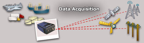 SARS data acquisition
In a press release SARS announced:
Secure Asset Reporting Services of Bellevue, WA is registering a growing base of ship owners and operators for its’ Long Range Identification Tracking service (LRIT). Using the SARS Automated Secure Vessel Tracking Service, ASVTS®, shipping companies’ operations, security and safety officers can monitor the location of their ships at sea, information that aids compliance with Coast Guard and International Maritime Organization safety, security, and environmental requirements. ASVTS® presents vessel information via a secure web Graphical User Interface (GUI) application that displays vessel’s current location and voyage history on nautical charts. In the event of a security alarm activation, the SARS software invokes procedures for notifying the designated responding authority. “We designed SARS to be hardware agnostic”, states Clayton Shelver, President of Secure Asset Reporting Services. “This means we work with a broad array of satellite communication devices, including common SSAS units (Silent Ship Alarms), and the value to the customer is that they can use the ship’s existing equipment and, with no additional hardware or software purchases, they can be up and running on SARS as soon as they register.”
No comments:
Post a Comment