Take a look at the nearby maps. At the top is an older map (Map 1) showing the dhow routes that have been sailed since ancient times. There's a pattern to the flow of dhows. Click on any of the maps to make them bigger.
The second map (Map 2) is my own presentation of modern sea lanes along the coast of east Africa - the red lines are the sea lanes. In the modern sea faring world ships, in theory, may have the freedom to choose their routes and the freedom of the open
 sea, etc, etc, but the practical reality is that merchant ships are driven by the cruel masters of time and money. For the owners of merchant ships time is money and any ship's master who decides to wander all over the ocean instead of taking the shortest, fastest route from one port to another will quickly be out of a job. Since there can only be one "shortest, fastest, safest route between two ports" that route becomes a sea lane. The seemingly chaotic world of ocean shipping is in many ways quite predictable. It is this predictability that the Somali pirates now rely on.
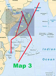
 Map 3 superimposes on those sea lanes the most recent ships attacks and hijackings. While the maps I used don't mesh exactly (and I am too lazy to make them fit) the point I am making is clear. The pirate attacks happen along the sea lanes. Why? Because, to paraphrase Willie Sutton, "that's where the ships are."
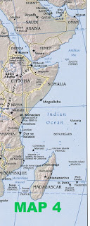
 Map 4 shows that the east African shipping route area is sprinkled with islands that must be avoided - again ensuring that the routes to be taken by merchant ships, yachts and fishing trawlers are predictable, and well known to crews of boats native to the area. Shipping transiting the area does not have unlimited sea room in which to maneuver.
Given all of the above, Somali pirates and their confederates may lie in wait along these predictable routes and wait for ships to come to them - as they inevitably will.
How do you thwart these pirates at sea? One possibility, in use in the Gulf of Aden, is to flood the sea lanes with sea policemen or naval forces who serve to deter or stops assaults on shipping in their beat area. Another possibility, especially when you have limited naval assets, and which is also in use in the Gulf of Aden, is to provide escorts to single or multiple ships as they transit the risk areas during periods when the pirates are likely to be active (low winds, day light hours or during periods of a bright moon) or escort ships that have proven to be at risk (low freeboard ships, slow transit speeds).
Put helicopters and UAVs in the air and learn the local fishing patterns to find the "fishing boats" that don't acty like the others. Use the helicopters to scout routes ahead of merchant ships.
 For the long transit down the eastern coast of Somalia, I propose a small variation on the convoy system. Points A, B and C on Map 5 become Ocean Convoy Collection Points (OCCPs) where ships desiring to transit piracy risk areas can gather for convoying to the other points.
Now, I know very well that what I said before about time and money are negative motivators for merchant ships to wait for convoys to be formed. And, after all, the odds of being nabbed by pirates are pretty slim. However, there are some risk adverse ship owners who will accept the convoys, especially if their insurance carrier will lower premiums for convoy participants.
I said it before and I'll say it again - given a chance - convoys work.
And, if you aren't going to invade Somalia to take out pirate havens, you don't really have a lot of other options.

No comments:
Post a Comment